Friday, 7 December 2012

Bomb Sight

As a child growing up in East London in the early 1970s I vividly remember the scattered derelict plots that were the vestiges of bombed-out buildings of the Blitz and the family stories that accompanied each, so and so was killed here, this bomb fell on such a date, the day the house was bombed, my mother pursued along the High Road by a marauding Messerschmidt. In our sideboard we had a scrapbook that held a copy of the bomb census map, published in the local paper just after the War ended. Fascinated I poured over it, looking for all the bombs that fell near our family home. So here is something rather special and evocative for me. Bomb Sight is an interactive map of the London Blitz, resulting from a JISC funded research project led by Dr Kate Jones in the Department of Geography at the University of Portsmouth. As well as being a fascinating piece of research, it is a great example of the power of GIS and web mapping to mash together disparate data to generate new insight and meaning, and has some really nice, clean cartography to boot.

Available via the project website and soon as an Android Ap with added augmented reality function, this is a very clever use of technology and personally carries me back to those childhood days of parental reminiscence and a not so distant and ominous past.

Thursday, 6 December 2012

Beyond Red: MS Remote Sensing of Landscape

Greatly enjoyed speaking at the Irish Quaternary Association annual symposium on Remote sensing: Applications in Quaternary Science, Archaeology and Landscape Management at the Geological survey of Ireland in Dublin.  Among some outstanding contributions the work of the Geological Survey of Ireland on mapping Quaternary sediments stood out.  The draft digital mapping was of exceptional quality and the maps themselves highly effective cartography.  GSI make much of their digital data freely available for use via their website, which is an example to all providers of public data.

My own presentation,on work using multispectral and hyperspectral airborne imagery for archaeological prospection and mapping is on slideshare and available below.

Saturday, 6 October 2012

Mind Maps

I remember first coming across the idea of mental maps, maps that reflect how we perceive and negotiate the environment around us, rather than reflect real space or concrete spatial relationships as a geography undergraduate.  I like this TED talk by graphic designer and cartographer Aris Venetikidis that elegantly describes how we mentally process space and movement through it and applies these concepts to the chaotic muddle of public transport in Dublin,  The results are elegant, meaningful visualizations of movement through the real and mental space of Dublin.  Impressive.

Tuesday, 11 September 2012

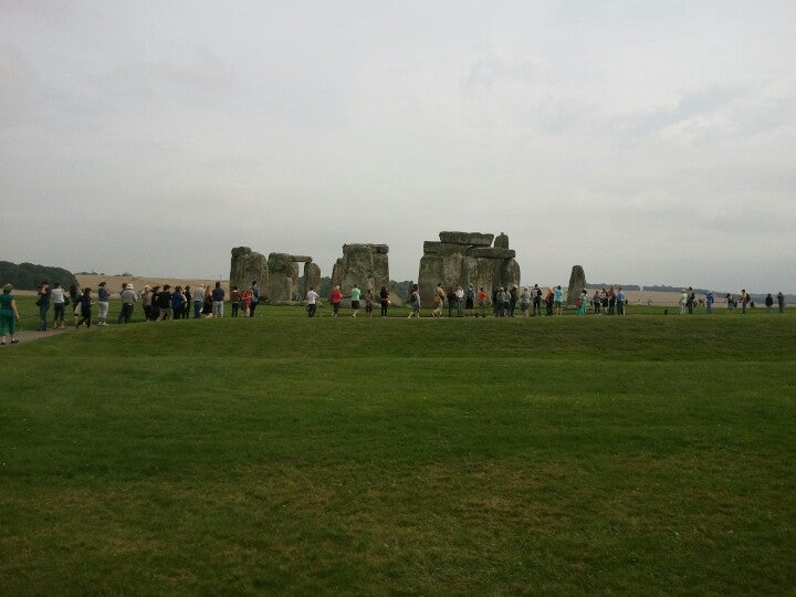
Found some stones in a field: A day of Stonehenge

September 11th 2012, one day at Stonehenge, one day of visitors, one day of tweeted pictures.  Found some stones in a field, definitely made by aliens...

Monday, 20 August 2012

Tweeting the Past

Not so very long ago capture and analysis of the live stream of geolocated tweets using Twitters streaming API was at the cutting edge of social science research. Caught up in the wow of it all we (at Vista) built an application to capture the live stream and after a 50 day proving run had ourselves 1.87 million tweets to analyse.  

50 days, 1.87 million geolocated tweets for the British Isles

Much of the analysis of twitter data has tended to focus on the spatial patters of use or the social networks revealed by the complex interrelationship of users  We we interested primarily on information relation to heritage, what do people tweet about heritage subject, where from, etc.  Results, it has to be admitted, were modest. Over 50 days only 22 tweets mentioning archaeology - including the wonderfully derogatory "goodness me archaeology is boring" (with more than a nod to Armstrong and Miller).  More interesting were spatial patterns of tweets in relation to heritage imbued landscapes, archetypally tweets from Stonehenge, displaying wonder at the monument and often accompanied by tweeter links to pictures.  This is richer fare for the study of reception of the past, and deserved more thought than we gave it at the time.  You can read about our work in the presentation below and in our paper A software system for data mining with twitter Proceedings of 2011, 10th IEEE International Conference on Cybernetic Intelligent Systems, CIS 2011, pp. 139–144, 2011.


And now, barely a year later, everybody is grabbing and mapping the live twitter stream.  Some of the applications are quite impressive, my personal favorite this live map of tweets from the Middle East, greatly revealing of the conflicts in Syria and elsewhere. What is still more astounding is that in the latest iteration of Bing Maps, Microsoft have added the facility to map live tweets against a Bing maps background. So, here, by way of experiment, live maps of all tweets from the Stonehenge area, and all tweets from the UK mentioning "archaeology". Remember, these are live maps and so most tweets will be sent during UK daylight hours  especially from Stonehenge.  


Saturday, 9 June 2012

Why SketchUp Matters...

Thinking about Google's sale of SketchUp a little more I begun to realize what makes me uneasy about this parting of the ways. It's not just the change of ownership from a company whose ethos I admire to one I am a little less comfortable with, its the fact that I think SketchUp, and particularly here I'm thinking about the free version, matters, and especially matters to the heritage community.  A threat to SketchUp is a threat to digital heritage in general and the democratization of the study of cultural heritage, the wrestling of heritage recording from the hands of the expert into a skilled community.


As an example, let me introduce you to the work of Tom Harvey. I don't know Tom, we've never met, although I've used his work, the freely offered fruit of his labour with SketchUp, especially his excellent Stonehenge model.  But what marks Tom's work out as exceptional is his steady methodical effort to single handedly create a digital version of his home town of Leominster, using SketchUp and sharing the results in the 3D Warehouse and on Google Earth.  This is digital heritage at its best, an authentic record of a community and its architecture at a point in time emerging from that community.  And what is the catalyst, well I'd argue it is the democratizing influence of SketchUp, its ease of use, its zero cost, its accessibility.  Meddle with that model and I fear that both the ethos that prompts the work of individuals like Tom and the ability to create it, vanishes.

What's Up SketchUp

Google have quietly parted company with their SketchUp product to Navigation company Trimble, best known for their range of navigation and survey grade GPS hardware. Now this raises all sorts of interesting questions. What are Google up to parting with a significant piece of the jigsaw that is the Google Earth hegemony?  What are Trimble up to, not noted for their consumer grade or navigation GPS, with a corresponding requirement for 3D urban environments, why are they interested in SketchUp and what market are they aiming to break in to?

The sale of SketchUp has some interesting implications for users.  For the time being, at least, Trimble have committed to honoring the free basic version of SketchUp and educational licensing, while obviously promoting the premium Pro version.  More interesting are the implications for 3D Warehouse contributors as Trimble have acquired, along with SketchUp, the assigned rights to the Warehouse.  Now this is interesting.  Google are a company that pride themselves on making money without being evil and their support of the free product, educational and philanthropic funding and general goodness is manifold (although let's not be naive here, they get up to some less shiny stuff too).  Trimble among their portfolio of products include a substantial defense element.  Now, how do you feel about your carefully crafted 3D models working alongside an unmanned drone, say circling silently over the streets of Gaza or the West Bank...Just asking.  Warehouse users have a limited period to op out of licensing their models to Trimble before its a done deal.

Wednesday, 6 June 2012

Mountains of Data

Enjoying the work of Edinburgh based Dutch artist Eddy Van Mourik, seen on his blogs Field and Mountains of Data.


Eddy qualified from the Edinburgh College of Arts with a degree mixing visual arts, landscape architecture and the earth sciences (nice!).  As well as working in game engines his present work involves an inciting blend of digital representation and the real world, I particularly like the reverse engineering of digital data into tangible real world art in pieces like NT 251732 (above).  I find the idea of mixing real and digital exciting (in all its forms) and this sort of reversal of the augmented reality paradigm is a fresh approach with some challenging perspectives on both.

Monday, 9 April 2012

Dear Esther

Dan Pinchbeck's Dear Esther, the seminal Half-Life 2 Mod funded by the AHRC has taken new life in this wonderful remodelling, undertaken in collaboration with Robert Briscoe at LittleLostPoly


The outstanding quality of the visual ascetics, narrative, music and voice acting of this superb little game cannot be emphasized enough, this is engrossing, though-provoking and moving interactive fiction at its best.  What I really want to draw attention to and praise however is the sheer visual quality of the natural landscapes as modelling by Robert Briscoe, all the more astounding as this is accomplished in Value's Source, which while an accomplished engine isn't an obvious choice for natural landscapes (step up CryENGINE here).  Briscoe's work is outstanding, technically amazing, scraping every last once of power from Source by stripping away all but the essential functions for this very low-key game.  What most impressed me is the sheer ascetic popwer of the landscapes, particularly the outside spaces and uplands, and the tangible sense of place this embodies.  This hypereal landscape takes on a salty, wind-swept solidity that is quite overwhelming at times.  I cannot praise this game enough.  If you haven't already, get it now.

Thursday, 5 April 2012

Photosynth on the iPhone

Microsoft Research are doing some pretty sexy things with visualization at the moment.  I've greatly enjoyed their Image Composite Editor (ICE, now at version 1.4.4) and already extolled the virtues of Photosynth for creating panoramic images from sequences of game rendered stills.  Trawling through the iOS App Store on my iPhone I was intrigued to discover an iOS version of Photosynth.  This neat little App turns my iPhone into a significantly useful handheld panorama creator, limited only by the relatively low resolution of the iPhone's camera (well on my ageing 3GS anyway). The end results can be uploaded to Photosynth.net for sharing.   I think the combination of iOS and Photosynth make a very capable device for capturing landscape and building panoramas.  Here, by way of example a bit of playing at Whitby Abbey.  I really like the ability to grab panoramas at will, in any circumstance that I can lay my hands on my iPhone, I can see lots of uses for this new toy - now, how can I lay my hands on a new generation iPad...

Sunday, 25 March 2012

AgiSoft PhotoScan

I'm impressed by this piece of work by former Birmingham Landscape Archaeology and GIS master's student Lawrence Shaw demonstrating the archaeological use of AgiSoft's PhotoScan photographic modelling software.  This nice demonstration of the software is of rock art found at Al Jassasiyah, Qatar and is compiled from eight different photographs taken from a pole.  OK, not landscape, but I'm very impressed by the fidelity of the model.  PhotoScan can output models derived from appropriate photographs in a variety of 3D object formats as well as those suitable for  digital elevation models.  I for one will be downloading the demo version to take it for a run, maybe at a bit of appropriate landscape, as well as the more usual objects and structures.

Lumion 3D

I've recently stumbled upon Lumion 3D visualization software, courtesy of the Digital Urban blog.  The free version of Lumion produces stunning output and can import greyscale heightmaps (from ArcGIS) and building and object models in collada format, exported from SketchUp. Output is in the form of high quality still images or rendered movies, the free version of the software adds a watermark in the top left corner. 


Above is a great example of the results achievable with the free version, this movie won the 2011 Lumion competition gaining a prize of $I0000 and a free copy of the software.  I have yet to see an easier to use piece of visualization software and I recommend immediate download and playing in time for the 2012 competition!

Tuesday, 20 March 2012

Outerra and Mirror Worlds

I'm grateful once again to the sharp-eyed Jack Hanson for pointing me, via New Scientist towards Outerra. Occupying a nice somewhere between Google Earth and Second Life, Outerra is a planetary rendering engine, allowing "seamless planet rendering from space down to the surface."


This is an interesting development, a true virtual world, unlike Google Earth for example which as an amalgam of remotely sensed data merely warehouses digital representations of the real world.  I'm put in mind of David Gelernter's Mirror Worlds - there are endless interesting possibilities.

The free technical demo is certainly impressive and there is considerable potential here for visualizing one's own data using the sandbox tools provided as part of the paid for version.