Wednesday, 30 June 2010

Climate Change, Archaeology and City Modelling

I've been continuing to explore Pixel Active's excellent CityScape, particularly as its focus on urban modelling takes me into new realms of visualisation.  The ability to import OpenStreetMap mapping and SketchUp models makes rapid visualisation of many cities easy.  Below, is a quick (really quick, about 10 minutes work) model of a corner of my old home, York.  Interesting, if a little quirky and certainly in need of more work.


On adding the River Ouse to my rough landscape, it struck me that CityScape's global water level functions would allow me to flood the landscape. Memories of York's dramatic winter 2000/2002 floods prompted the following crude visualisations of somewhat more water around Clifford's Tower than I remember.


Although this crude visualisation lacks an underlying terrain model, and so any pretence of credibility, it strikes me that this function might be adapted to look at one impact of future climate change in river valleys; flooding. Climate change and cultural heritage has concerned me and other colleagues elsewhere and with other hats on, but perhaps visualisation might bring home the potential real impact of climate change on cultural heritage more than words alone.  

Tuesday, 29 June 2010

Painting the Landscape

A request to provide images of Stonehenge with the Cursus barrow group in the background had me pondering the limitations of my Ordnance Survey based terrain model, which of course includes no such details.  In the absence of lidar terrain data for the study area (unless of course English Heritage would like to hand some over)  I've come up with an inexact compromise.


Using the Ordnance Survey mapping, which shows barrow locations, I've created a binary mask in ArcGIS in which the earthworks of barrows are shown in solid black.


Imported into CryEngine as a texture mask, and with a suitably garish texture, this serves as a visual guide for manually tweaking the terrain with Sandbox's terrain modification tools, in effect painting the barrows on to the landscape.  With sensible textures restored things begin to look reasonable.


The results are not so bad, with correctly located barrows that, with care, can be sculpted into approximately the right size and profile.  Better of course to begin with accurate survey data, but for now at least this meets the requested need.

Friday, 25 June 2010

Vegetation and Views: Leskernick Revisited Pt. 3

Leskernick in CityScape

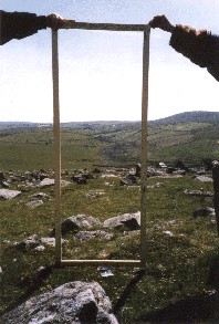
Back to the theme of investigating the landscape of Leskernick on Bodmin Moor.  The rapid landscape modelling facilities of PixelActive's CityScape, coupled with its rather wonderful cloud modelling facilities tempted me to explore using it to model part of Bodmin Moor.  So, here is a rough first attempt at visualising my 16 x 16km study area.  I've found that CityScape's import of GIS terrain data in Geotiff format is a little uneven, perhaps an issue with ArcGIS's implementation of Geotiff  as I've experienced similar problems with other Arc derived Tiffs in the past.  To get around this I've used a greyscale heightmap, "baked" onto a terrain set up with a frame of correct dimension and projection derived from a shapefile.  This seems to work well.  So, below, in homage to the original photograph, a rapid visualisation of the view through "Bender's door".  Interesting to note how changing atmospherics alter the viewing distance as the near horizon recedes into cloud.


I'll be experimenting more with CityScape for this project as I feel sure that it has much to offer and although lacking the first-person avatar-based facilities of CryEngine, its rapid landscape modelling and realistic clouds are perhaps more suited to this endeavour.

Thursday, 24 June 2010

Stone Casualties

The recent Coalition Government cancellation of the new Stonehenge Visitors Centre and associated re-routing of the A344, along with a great post in Andrew Crook's GIS and Agent Based Modelling blog inspired me to download a trial of Pixel Active's City Scape, city modelling and simulation software and try it out for archaeological landscape modelling.


The promise of GIS data input and the ability to use 3D models in industry standard formats, coupled with sophisticated visualisation and agent-based traffic simulation bodes well and immediately lends itself to a quick visualisation of the sad state of Britain's most iconic ancient monument.  So here, in a short movie, the imprisoned stones, for now at least, to remain locked within late 20th century clutter.  


Landscape based on Ordnance Survey landform profile terrain data and MasterMap mapping using again Tom Harvey's excellent SketchUp model of the stones themselves.  I'm impressed with City Scape and will return to it again in the near future.

Wednesday, 23 June 2010

Visualising Terrestrial Laser Scanning

The idea of pointing a terrestrial laser scanner at the ground, rather than at some sort of building or structure, may not be entirely new, but the question remains what to do with the huge quantities of data such idiocy generates.

The data visualised here is of the north-eastern entrance of the Iron Age hillfort at British Camp, Little Malvern and was collected as part of the coursework of one of our postgraduate students taking the MA programme in Landscape Archaeology, GIS and Virtual Environments.  He used a Leica HDS3000 TLS, hauled to the top of the hill twice (it failed to work the first time) and collected 3.2 million xyz data points from three survey stations.  The point data was stitched together in Leica Cyclone, but then, what?


Effective data exploration was undertaken in the hugely capable Quick Terrain Modeler (usually used for airborne lidar data), but decimating the data to allow visualisation in ArcGIS and ArcScene produced disappointing results. Here are the same data visualised using CryEngine 2 and a little imagination.


Fair I think to say that the metrical accuracy of the CryEngine model is way below that of ArcGIS or QT Modeler.  X-Y co-ordinates are fine, although limited to 1m spatial resolution, somewhat below the centimetre level of the original data. The principal problem with CryEngine is the Z scaling, limited to a range of 256 increments from lowest to highest value (that is the 256 shades of grey possible in an 8-bit heightmap).  At British camp the vertical range in the original data is 90m, so in our CryEngine  model each heightmap increment is equal to 35cm with the inevitable compromise in resolution.

Nonetheless, the dressed terrain model, with texture, vegetation and effects, is a pleasing, interactive rendering of the landscape which capture the original more effectively that the metrically correct, but dry 2D visualisations.


So what is going on here?  For my money, these lower resolution game-based visualisations more truely present landscape in the way our brains cognitively interact with the world around us.  We don't see millions of data points, we see impressions of landscape, tussocky grass, the fleeting movement of birds and the interplay of light and shadow on the land.  So, feed the mind with familiar fare and happy sensory engagement results.  And what of those lost millions of points?  Still there in the ether for analysis if needed...

Thursday, 17 June 2010

Game Space

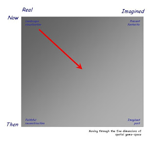
As I've played about with these game-based reconstructions of landscape and space it has increasingly struck me that the very mutability of the worlds so-created needs some codified explanation.  It's true that all archaeological visualisation or reconstruction is open to interpretation, judgements over what partly known and understood things and places looked like in the past, even what Rumsfieldian unknown, suspected or unsuspected things may have been and where. It's axiomatic that things that we have accurately recorded (to the millimetre with GPS, laser scanning, lidar or whatever) are where we say they are, for the present at least (the now and real), but what of the part-known or suspected, the interpolated reconstructed past of scientific analysis (neolithic vegetation reconstructed from the pollen record - a faithful reconstruction of the past) or the imaginative past of the half-understood (the shell-keep of Totnes castle superimposed on the motte of Laxton because there may have been a shell-keep, but we don't know what it looked like) this is a richer, but more tentative landscape of the imagined past. And in the pervasive paradigm of games, what about an alternative now (Half-life perhaps) or the seductive quasi-mystical alternative present of numerous writers (Christoper Priest's Dream of Wessex if you like, or indeed Hardy's own Wessex, "a partly-real, partly-dream country", a case of the present fantastic).  
So here is an attempt to codify that variety in a theoretical nutshell, five-dimensional game space, assuming we know the where of our start point (the latitude, longitude and elevation) we travel off in other dimensions of then and imagined to end up who knows where.  Just perhaps we should remember to think about how we have ended up here when we arrive, although perhaps only an archaeologist might consider that vector important, to the free avatar it isn't important at all...

Saturday, 12 June 2010

Building Sterile Landscapes

Together with colleges at Birmingham and Nottingham I have spent a good many years exploring the earthworks of Laxton's fine medieval motte and bailey castle.  For those who are interested many of the details of our work are available on a dedicated website and in fact some of my early game-based visualisation experiments, using the Medieval Total War engine, were focused on Laxton.While that was altogether an unsatisfactory experience it did force me to consider more sophisticated technology, and so to CryEngine.

Our fieldwork at Laxton has always been an ad-hoc affair, student and community focused, and one of the outcomes I would still very much like to achieve is to return a version of that work to community ownership.  I've ruminated on whether game-based visualisation is one was to achieve that.  A game provides an elegant, accessible portal into the technicalities of survey, and one that can seamlessly move from real and now to then and maybe (back to that five-dimensional space).  However, recent reading is causing me to reflect on the whole game experience.  What draws us in to the game world? Dan Pinchbeck's work reminds us that it is narrative and particularly elements of narrative beyond the ludic, that capture attention.

So, while our present game-based visualisation of Laxton attempts to recreate the now and real of the monument and landscape, and entice users into exploration and discovery, rather than passive reception, this is on one level a sterile vision, the roving eye of the avatar moves over the landscape without motive or intent.  Perhaps what is needed is a narrative to motivate and inform.  Co-opting not just the technology of game engines, but the ludic and the narrative, now there is a challenge...


Pinchbeck, D. 2008. Story and Recall in First Person Shooters. International Journal of Computer Games Technology

Friday, 11 June 2010

Unity

I've recently been working with Unity Technologies Unity3d game engine. Unity is attractive as the basic version is free to download and use, and the editor pretty easy to get to grips with (although I admit to struggling to master camera control).  Its great strengths are a graphically stunning 3d engine and the ability to compile the same basic level for delivery as a standalone file for a range of platforms or via a web-browser plug-in.  Since this is a stripped back game engine, not hung on a particular game, the combat element that is so hard to get around in CryEngine is wholly absent, a refreshing change.

Unity appears to work well with greyscale heightmaps for defining real-world terrain (although confusingly the editor appears to mirror the x and y co-ordinates of the original image) and there are a range of pre-fab objects and textures to make level creation possible straight from the box, so to speak.  I'm impressed and so will be working to get to grips with the finer points of Unity in the hope that it may provide a better solution than my favourite, CryEngine, in the longer term.

Thursday, 10 June 2010

Ideas of Landscape

One of the key ideas behind using computer games to visualise archaeological landscapes is that they take us away from the god-like view from above that typical computer-based visualisation provides.  In Ideas of Landscape, Matthew Johnson reflects on the dichotomy between the romantic, Wordsworthian view of landscape, rooted amongst other things in the view from above, and Hoskins' assertion that "the real work [in the study of landscape] is accomplished by the men and women with muddy boots..."

Computer visualisation, particularly of remotely collected landscape data (for example the airborne lidar used here) has almost inevitably forced us to explore only one path; landscapes become data objects, interpreted as a whole and understood as abstract entities, devoid of sense and experience.

The first person view of game-based visualisation places us back in the realm of "muddy boots" landscape is explored and experienced, like Hoskins we "explore England on foot".  Does that improve our understanding of landscape?  At one level probably not, arguably morphology of landscape is best appreciated from above, but landscape is more than form and function, and the relationship between elements of landscape is better appreciated from the ground.  Examine if you will the earthworks of West Burton deserted village, in Nottinghamshire.  


The lidar-based terrain model perfectly delineates the banks, ditches, hollow-ways and house platforms of this former river-side village.  But does it provide any sense of what it is like to be amongst that landscape, its scale, the interplay of shadows and light both revealing and exposing its intricacies.  Perhaps using the first-person view of a game some of the complexity of discovery and understanding are recaptured?  Does it help us to experience our technically precise survey data is this way?  On one level I think that it does, at least by forcing us to consider those aspects of understanding achievable only from the ground - a sense of place and time.  Of course these digital visions are just that "visions" elaborate fictions with a kernel of truth, this is a five dimensional space, location, time and imagination (x,y,z,t,i) the extent to which we manipulate imagination to control meaning in these hyper-real spaces is central to their power, but that's another topic...


Hoskins, W.G. 1955. The Making of the English Landscape. London, Hodder & Stoughton.
Johnson, M. 2007. Ideas of Landscape. Malden, Blackwell Publishing.


Wednesday, 9 June 2010

Choose Your Reality

We have become used to seeing the world rendered on a computer screen, almost unquestioningly we take in the mirror world of Google (maps, earth streetview) the hyper-reality of three dimensional buildings superimposed on global high resolution imagery.  There is little pause to question what we are seeing, the integrity of the images, or the extent to which reality is morphed into a digital vision of the real.  Computer games add yet another distorting lens between the real world and the world as we experience it on screen.  So, I invite you to choose your reality, wonder what the differences between visions mean and if they are even relevant when immersive visualistion is so easily achieved (for the price of a £10 computer game).  If your only experience of a place is the digital envisioning of that place, who is to say that is not the most real.

Choose your reality...

CryEngine


Google StreetView


Google Earth


with apologies for slow page loading...

.

Tuesday, 8 June 2010

More Stonehenge

A little movie sequence of the Stonehenge environs FarCry level, just because I like it really.


It could be significantly improved if some of the other earthworks in vicinity of the henge were added, the Avenue, Cursus and various barrows. I'm working on sourcing sufficiently detailed data for these to allow generation of appropriate height maps.

Friday, 4 June 2010

Stonehenge Demo FarCry Level

A few more hours work have completed a reasonable demonstration FarCry level for the landscape around Stonehenge.  Using Ordnance Survey terrain data and correctly placed vegetation, but dispensing with the modern roads and field boundaries, the final result is a sort of fantasy hype-real  Salisbury Plain.


The final product, including rather exaggerated henge earthworks,  looks pretty convincing and is set up to play as a free-for-all multiplayer map, allowing up to four players to explore the landscape simultaneously (no weapons though!).  I've added a few weather effects to make exploration interesting, wander too far from the stones and it starts to rain. 


In order to stop players falling off the map, in-game time is limited to two minutes, enough to explore the stones and their environs, but not enough to reach the edge of the 2 x 2km map, just right for a public display of the utility of games for archaeological visualisation, sufficient time to get a feel for things, but not so long that one person will hog the display.


All in all it provides a pretty convincing introduction to game-based visualisation.  Our geophysical survey team is hitting Salisbury Plain with a variety of high tech kit in the next few weeks, next up may be an attempt to visualise the hidden sub-surface in-game.


Improving on Stonehenge

In preparation for an interactive demonstration for a University open day I've been working on improving the Stonehenge model a little.  The new terrain heightmap is based on Ordnance Survey data, with textures based on landcover extracted from contemporary mapping. I've also added woodland where it is presently mapped and attempted to represent the earthworks of the henge itself within the terrain model by "painting" banks and ditches onto the greyscale heightmap.  Quite a bit of work to do yet, but here is a quick image of Stonehenge silhouetted by the setting sun viewed from the east, close to the present A344 outside just Amesbury.

Thursday, 3 June 2010

Vegetation and Views: Leskernick Revisited Pt. 2

Building the Terrain Model
The Leskernick terrain model is built using Ordnance Survey profile DTM data from the Edina Digimap service. One might equally have used lower resolution panorama data from the Ordnance Survey OpenData collection. The DTM covers an area of approximately 625km2 at a spatial resolution of 5m.  A rapid assessment of areas visible from the top of Leskernick Hill was used as a basis to select a focus area of roughly 16 x 16km, suitable for modelling in CryEngine.

The 5m resolution OS data was degraded to a lower resolution within ArcGIS, before selecting a square area 16384x 16384m and exporting this as a greyscale heightmap.


Using Sandbox a new level 2048 x 2048 units in size at 8m pixel resolution was created and the greyscale heightmap used to generate terrain.  After rough texturing and lighting the result is a CryEngine based map of the of Bodmin Moor centred on Leskernick.  Easy really, although the terrain looks a bit ropey up close and the final product will need some more work in ArcGIS and probably a smaller lower resolution heightmap for CryEngine.

Wednesday, 2 June 2010

Landscapes and Light

Archaeologists often rely on lighting effects, particularly low winter sunlight, to reveal subtle aspects of landscape. The animated sequence below uses CryEngine2 to visualise lighting from dawn to dusk on a winter day from an elevated view of the earthworks of West Burton DMV.


The West Burton terrain model is based on 1m resolution airborne lidar, filtered to remove vegetation and buildings. While this is hardly a ground-breaking use of computer game software for visualisation, it does highlight the potential for game engines to tangentially address some more traditional archaeological concerns.

Tuesday, 1 June 2010

Vegetation and Views: Leskernick Revisited Pt. 1

Over the next week or so I will be working on and off on an experiment using CryEngine2 to to investigate the views from the Bronze Age settlement at Leskernick, Bodmin  made famous by the phenomenological musings of Barbara Bender (Bender et al 1997) as epitomised in her photographs of views "framed" from the doors of the prehistoric houses.  Bender's work was critiqued by Chapman and Geary (2000) who pointed out that the ample evidence of past environment from the pollen record might suggest that vegetation, particularly Oak and Alder woodland, might have dramatically altered some of the views  in antiquity. So, using a combination of GIS modelling of landscape and vegetation, and CryEngine2 for visualisation, I plan to re-explore Bender's views of Bronze Age Bodmin.


BENDER, B, HAMILTON S, & TILLEY. C.1997. Leskernick: stone worlds: alternative narratives; nested landscapes. Proceedings of the Prehistoric Society 63: 147-78.
CHAPMAN H.P. & GEAREY B.R. 2000. Palaeoecology and the perception of prehistoric landscapes: some comments on visual approaches to phenomenology. Antiquity 74: 316–319.