Showing posts with label CryEngine 2. Show all posts

Wednesday, 21 September 2011

Different Visions

Back to Laxton tonight, wearing a by now slightly unfamilar hat, to talk to the Laxton History Group about the past excavation and survey work in the village and castle.

I can't resist including one of the CryEngine visualizations of the castle survey in the presentation, and have settled for that produced in CE2:


It strikes me how different the same basic data looks in CryEngine 1:


Nothing deep here, but it strikes me as how CE1 has something of a cartoonish, fantastical feel about it.  Now we may deride that as lack of photo-realism, something that undermines the authenticity of the visualization, and if we did we might have a point.  But there's also something attractive about this, rather like naive art, the studied lack of realism invites a different kind of engagement and reject criticism for not looking real enough.  This might just be my liking for the speed and simplicity of CE1 speaking, but if game based rendering of landscape is about more than simply realism (and I believe it is) then maybe naivety and a simple pallet have something to offer.

Wednesday, 7 September 2011

Tara

One of the nice things to come out of Technological Advances in Landscape and Heritage Management Recording has been the chance to collaborate with colleagues in Ireland on some experimental visualization.  


I'm very grateful to the Discovery Programme for supplying some of their very high resolution Fli-Map airborne lidar (c.2m ground resolution) to play about with, including attempting a visualization of the iconic Hill of Tara in CryENGINE.

Tara is an interesting landscape to work with.  The earthworks are well defined and the lidar data quite startling in its clarity, there are also numerous crowd-sourced ground level photographs to work from.  Working in CE1 was a little disappointing, although layering textures from derivatives of the lidar terrain data (slope mapping, solar insolation modelling, etc) shows promise.  Far better at the moment is CE2, with its much improved lighting and vegetation.  Below is a rough render of the initial model, with more to follow in due course. 


Getting the vegetation right here is key and requires considerably more work before even beginning to think about adding arcitectural detail. Great to have such fantastic data to work with.

Thursday, 11 August 2011

Technological Advances in Landscape and Heritage Management Recording

Here, for the record, my presentation given at Technological Advances in Landscape and Heritage Management Recording in Dublin on Friday.  An excellent, useful and enjoyable day with some very interesting presentations, particularly focused on high resolution airborne and terrestrial lidar.  I was really taken by the work of Dr Dave Walker on the Nottingham caves (good enough to deserve its own post, so more later) and the Scottish Ten, mysterious name, but great work, again deserving its own post. Since I managed to give the wrong version of my presentation, anyone interested in what I had to say will get a fuller picture from the below...  

Sunday, 7 August 2011

Recounting the Landscape: Laxton Castle CryENGINE 2

Part of the aim of "Lasers, Landscapes and Muddy Boots" is to demonstrate the way in which game engines can place us as archaeologists physically within the landscape of our surveyed monuments, albeit virtually.  As a demonstration I've produced this short walkthrough of our survey of Laxton castle, based on field collected GPS data.


Produced using CryTek's CryENGINE 2, it lacks the ludic elements of earlier CryENGINE 1 models of the same site, but has a greater degree of visual fidelity - it looks more like the real thing.  Just the thing to get across the point that standing inside our survey data and rewalking the same fields, getting digital mud on our boots, may bring new insight. In the words of Tilley "To understand a landscape truly it must be felt, but to convey some of this feeling to others it has to be talked about, recounted, or written and depicted."

Friday, 20 August 2010

Wednesday, 23 June 2010

Visualising Terrestrial Laser Scanning

The idea of pointing a terrestrial laser scanner at the ground, rather than at some sort of building or structure, may not be entirely new, but the question remains what to do with the huge quantities of data such idiocy generates.

The data visualised here is of the north-eastern entrance of the Iron Age hillfort at British Camp, Little Malvern and was collected as part of the coursework of one of our postgraduate students taking the MA programme in Landscape Archaeology, GIS and Virtual Environments.  He used a Leica HDS3000 TLS, hauled to the top of the hill twice (it failed to work the first time) and collected 3.2 million xyz data points from three survey stations.  The point data was stitched together in Leica Cyclone, but then, what?


Effective data exploration was undertaken in the hugely capable Quick Terrain Modeler (usually used for airborne lidar data), but decimating the data to allow visualisation in ArcGIS and ArcScene produced disappointing results. Here are the same data visualised using CryEngine 2 and a little imagination.


Fair I think to say that the metrical accuracy of the CryEngine model is way below that of ArcGIS or QT Modeler.  X-Y co-ordinates are fine, although limited to 1m spatial resolution, somewhat below the centimetre level of the original data. The principal problem with CryEngine is the Z scaling, limited to a range of 256 increments from lowest to highest value (that is the 256 shades of grey possible in an 8-bit heightmap).  At British camp the vertical range in the original data is 90m, so in our CryEngine  model each heightmap increment is equal to 35cm with the inevitable compromise in resolution.

Nonetheless, the dressed terrain model, with texture, vegetation and effects, is a pleasing, interactive rendering of the landscape which capture the original more effectively that the metrically correct, but dry 2D visualisations.


So what is going on here?  For my money, these lower resolution game-based visualisations more truely present landscape in the way our brains cognitively interact with the world around us.  We don't see millions of data points, we see impressions of landscape, tussocky grass, the fleeting movement of birds and the interplay of light and shadow on the land.  So, feed the mind with familiar fare and happy sensory engagement results.  And what of those lost millions of points?  Still there in the ether for analysis if needed...

Thursday, 3 June 2010

Vegetation and Views: Leskernick Revisited Pt. 2

Building the Terrain Model
The Leskernick terrain model is built using Ordnance Survey profile DTM data from the Edina Digimap service. One might equally have used lower resolution panorama data from the Ordnance Survey OpenData collection. The DTM covers an area of approximately 625km2 at a spatial resolution of 5m.  A rapid assessment of areas visible from the top of Leskernick Hill was used as a basis to select a focus area of roughly 16 x 16km, suitable for modelling in CryEngine.

The 5m resolution OS data was degraded to a lower resolution within ArcGIS, before selecting a square area 16384x 16384m and exporting this as a greyscale heightmap.


Using Sandbox a new level 2048 x 2048 units in size at 8m pixel resolution was created and the greyscale heightmap used to generate terrain.  After rough texturing and lighting the result is a CryEngine based map of the of Bodmin Moor centred on Leskernick.  Easy really, although the terrain looks a bit ropey up close and the final product will need some more work in ArcGIS and probably a smaller lower resolution heightmap for CryEngine.

Wednesday, 2 June 2010

Landscapes and Light

Archaeologists often rely on lighting effects, particularly low winter sunlight, to reveal subtle aspects of landscape. The animated sequence below uses CryEngine2 to visualise lighting from dawn to dusk on a winter day from an elevated view of the earthworks of West Burton DMV.


The West Burton terrain model is based on 1m resolution airborne lidar, filtered to remove vegetation and buildings. While this is hardly a ground-breaking use of computer game software for visualisation, it does highlight the potential for game engines to tangentially address some more traditional archaeological concerns.

Tuesday, 1 June 2010

Vegetation and Views: Leskernick Revisited Pt. 1

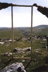
Over the next week or so I will be working on and off on an experiment using CryEngine2 to to investigate the views from the Bronze Age settlement at Leskernick, Bodmin  made famous by the phenomenological musings of Barbara Bender (Bender et al 1997) as epitomised in her photographs of views "framed" from the doors of the prehistoric houses.  Bender's work was critiqued by Chapman and Geary (2000) who pointed out that the ample evidence of past environment from the pollen record might suggest that vegetation, particularly Oak and Alder woodland, might have dramatically altered some of the views  in antiquity. So, using a combination of GIS modelling of landscape and vegetation, and CryEngine2 for visualisation, I plan to re-explore Bender's views of Bronze Age Bodmin.


BENDER, B, HAMILTON S, & TILLEY. C.1997. Leskernick: stone worlds: alternative narratives; nested landscapes. Proceedings of the Prehistoric Society 63: 147-78.
CHAPMAN H.P. & GEAREY B.R. 2000. Palaeoecology and the perception of prehistoric landscapes: some comments on visual approaches to phenomenology. Antiquity 74: 316–319.

Sunday, 30 May 2010

Dynamic Lighting

One of the things I particularly like about CryEngine 2 is its implementation of dynamic lighting, great for seeing the effects of changing sunlight on the landscape.


This simple video sequence shows a static view of Laxton Castle from sunrise to sunset, compressing a day into 90 seconds.  True, not much happens but the lighting effects at dawn and dusk are great and there is considerable potential for exploring interplay of light and landscape further.