I remember first coming across the idea of mental maps, maps that reflect how we perceive and negotiate the environment around us, rather than reflect real space or concrete spatial relationships as a geography undergraduate. I like this TED talk by graphic designer and cartographer Aris Venetikidis that elegantly describes how we mentally process space and movement through it and applies these concepts to the chaotic muddle of public transport in Dublin, The results are elegant, meaningful visualizations of movement through the real and mental space of Dublin. Impressive.
Showing posts with label Visualisation. Show all posts
Showing posts with label Visualisation. Show all posts
Saturday, 6 October 2012
Monday, 9 April 2012
Dear Esther
Dan Pinchbeck's Dear Esther, the seminal Half-Life 2 Mod funded by the AHRC has taken new life in this wonderful remodelling, undertaken in collaboration with Robert Briscoe at LittleLostPoly
The outstanding quality of the visual ascetics, narrative, music and voice acting of this superb little game cannot be emphasized enough, this is engrossing, though-provoking and moving interactive fiction at its best. What I really want to draw attention to and praise however is the sheer visual quality of the natural landscapes as modelling by Robert Briscoe, all the more astounding as this is accomplished in Value's Source, which while an accomplished engine isn't an obvious choice for natural landscapes (step up CryENGINE here). Briscoe's work is outstanding, technically amazing, scraping every last once of power from Source by stripping away all but the essential functions for this very low-key game. What most impressed me is the sheer ascetic popwer of the landscapes, particularly the outside spaces and uplands, and the tangible sense of place this embodies. This hypereal landscape takes on a salty, wind-swept solidity that is quite overwhelming at times. I cannot praise this game enough. If you haven't already, get it now.

Thursday, 5 April 2012
Photosynth on the iPhone
Microsoft Research are doing some pretty sexy things with visualization at the moment. I've greatly enjoyed their Image Composite Editor (ICE, now at version 1.4.4) and already extolled the virtues of Photosynth for creating panoramic images from sequences of game rendered stills. Trawling through the iOS App Store on my iPhone I was intrigued to discover an iOS version of Photosynth. This neat little App turns my iPhone into a significantly useful handheld panorama creator, limited only by the relatively low resolution of the iPhone's camera (well on my ageing 3GS anyway). The end results can be uploaded to Photosynth.net for sharing. I think the combination of iOS and Photosynth make a very capable device for capturing landscape and building panoramas. Here, by way of example a bit of playing at Whitby Abbey. I really like the ability to grab panoramas at will, in any circumstance that I can lay my hands on my iPhone, I can see lots of uses for this new toy - now, how can I lay my hands on a new generation iPad...
Sunday, 25 March 2012
AgiSoft PhotoScan
I'm impressed by this piece of work by former Birmingham Landscape Archaeology and GIS master's student Lawrence Shaw demonstrating the archaeological use of AgiSoft's PhotoScan photographic modelling software. This nice demonstration of the software is of rock art found at Al Jassasiyah, Qatar and is compiled from eight different photographs taken from a pole. OK, not landscape, but I'm very impressed by the fidelity of the model. PhotoScan can output models derived from appropriate photographs in a variety of 3D object formats as well as those suitable for digital elevation models. I for one will be downloading the demo version to take it for a run, maybe at a bit of appropriate landscape, as well as the more usual objects and structures.
Lumion 3D
I've recently stumbled upon Lumion 3D visualization software, courtesy of the Digital Urban blog. The free version of Lumion produces stunning output and can import greyscale heightmaps (from ArcGIS) and building and object models in collada format, exported from SketchUp. Output is in the form of high quality still images or rendered movies, the free version of the software adds a watermark in the top left corner.
Above is a great example of the results achievable with the free version, this movie won the 2011 Lumion competition gaining a prize of $I0000 and a free copy of the software. I have yet to see an easier to use piece of visualization software and I recommend immediate download and playing in time for the 2012 competition!
Above is a great example of the results achievable with the free version, this movie won the 2011 Lumion competition gaining a prize of $I0000 and a free copy of the software. I have yet to see an easier to use piece of visualization software and I recommend immediate download and playing in time for the 2012 competition!
Tuesday, 20 March 2012
Outerra and Mirror Worlds
I'm grateful once again to the sharp-eyed Jack Hanson for pointing me, via New Scientist towards Outerra. Occupying a nice somewhere between Google Earth and Second Life, Outerra is a planetary rendering engine, allowing "seamless planet rendering from space down to the surface."
This is an interesting development, a true virtual world, unlike Google Earth for example which as an amalgam of remotely sensed data merely warehouses digital representations of the real world. I'm put in mind of David Gelernter's Mirror Worlds - there are endless interesting possibilities.
This is an interesting development, a true virtual world, unlike Google Earth for example which as an amalgam of remotely sensed data merely warehouses digital representations of the real world. I'm put in mind of David Gelernter's Mirror Worlds - there are endless interesting possibilities.
The free technical demo is certainly impressive and there is considerable potential here for visualizing one's own data using the sandbox tools provided as part of the paid for version.
Sunday, 13 November 2011
Making Something Different
Enjoyed speaking the the CBA East Midlands group in Market Overton yesterday. Part of a programme packed with interesting and varied stuff, including one again Dave Walker on the excellent Nottingham Caves Survey
Talking about using airborne lidar in landscape archaeology I think I spent too long dwelling on the relatively mundane choices of data visualization techniques and how they enhance our ability to identify and interpret archaeological information in lidar elevation models. But beyond traditional visualization is the enticing world of game-based immersive visualization of those same data, a better way to engage with the density and complexity of high-volume survey data. I was pleased that suggesting this approach went down well with a general non academic audience who (I'm sue I will be forgiven) were on the whole somewhat older than the usual conference audience. To me this seems hopeful proof that the concept of community digital heritage has some currency and that computer-based visualization is neither too esoteric nor too divorced from the common currency of community archaeology to find a place.
Friday, 16 September 2011
Stonehenge
Two exciting pieces of research affecting Stonehenge have been pointed out to me and are too good not to pass on. The English Heritage funded 3D Stonehenge model has used high resolution terrestrial laser scanning to produced an unparalleled, accurate three-dimensional model of the stones.

Meanwhile, at Bournemouth University the team responsible for one of the recent campaigns of fieldwork at Stonehenge have completed the Google Under the Earth: Seeing-beneath-Stonehenge project. Funded by the Google Research Program. Birmingham Postgraduate Lawrence Shaw has worked on this project and blogs about it here.
Great work, and nice visualization in both cases.
Thursday, 8 September 2011
Exploring Visibility and Atmospheric Occlusion in CryEngine
The role of visual appreciation of landscape has taken a
leading role in the archaeology of landscape, encouraged both by theoretical
approaches and the utility of GIS softwares for automatic analysis of the
visual characteristics of large landscapes.
Various writers have critiqued GIS studies of visibility and proposed
enhancements to and refinements of visibility studies (eg. Llobera 1996 and 2000; Ogburn
2006). In essence arguments for the refinement
of visibilities studies focus on the need to appreciate the impact of range,
view direction and target size on visibility. Additionally, a number of authors
have pointed out the shortcomings of both theoretical and practical approaches
to visibility studies, in particular the fact that many studies ignore or
misrepresent the potential impact of vegetation and past vegetation patterns on
landscape and visibility.

I have been experimenting with using CryEngine to model
different degrees of visual occlusion of landscape, based on atmospheric fog and rain. Sandbox conveniently allows varying vegetation
scenarios for the same landscape to be stored as layers that may be turned on
and off to explore the visual impact of changes in vegetation. Sandbox's environment controls allow
alteration of the character, density and occlusion distance of atmospheric fog
and addition the impact of rain on visibility may be simulated through particle
effects. The graphics here illustrate CryEngine
simulations of the effect of increasingly dense atmospheric fog (with view distance decreasing from 200m to 500m) and the addition
of rain on visibility of Stonehenge as viewed from The Cursus, a distance of
just over 2km, and can be compared with a traditional GIS-derived
two-dimensional viewshed diagram from the same location.

I think this approach has some potential for exploring changing visibility in landscapes where views and indivisibility are considered significant. I'll be exploring different vegetation patterns in a similar light in the near future.
Llobera, M. 1996. Exploring the topography of mind: GIS, social space and archaeology. Antiquity 70, 612-22.
Llobera, M. 2001. Building past landscape perception with GIS: understanding topographic prominence. Journal of Archaeological Science 28,
1005-14.
Ogburn, D.E. 2006. Assessing the level of visibility of cultural objects in past landscapes. Journal of Archaeological Science 33,
405-13.
Wednesday, 7 September 2011
Tara
One of the nice things to come out of Technological Advances in Landscape and Heritage Management Recording has been the chance to collaborate with colleagues in Ireland on some experimental visualization.

I'm very grateful to the Discovery Programme for supplying some of their very high resolution Fli-Map airborne lidar (c.2m ground resolution) to play about with, including attempting a visualization of the iconic Hill of Tara in CryENGINE.
Tara is an interesting landscape to work with. The earthworks are well defined and the lidar data quite startling in its clarity, there are also numerous crowd-sourced ground level photographs to work from. Working in CE1 was a little disappointing, although layering textures from derivatives of the lidar terrain data (slope mapping, solar insolation modelling, etc) shows promise. Far better at the moment is CE2, with its much improved lighting and vegetation. Below is a rough render of the initial model, with more to follow in due course.

Getting the vegetation right here is key and requires considerably more work before even beginning to think about adding arcitectural detail. Great to have such fantastic data to work with.
Friday, 19 August 2011
The Scottish Ten
More from Technological Advances in Landscape and Heritage Management Recording. The Scottish Ten is another fine example of a terrestrial laser scanning project of epic and imaginative scale producing beautifully visualized results. In its own words "A groundbreaking international 3D scanning project to digitally document Scotland’s five World Heritage Sites and five international ones". Work has employed a variety of scanning techniques to document sites as diverse as St Kilda, Neolithic Orkney and Mount Rushmore.
I'm particularly taken by the effectiveness of their translation of laser scanning from point cloud to photo-realistic models (viz the movie above) and crave more information on their methodology. The impressive pre-rendered visualizations are a great example of what laser scanning is capable of - but I'd love to see the same data ported to a game-engine for real-time interactive exploration.
Tuesday, 16 August 2011
The City Beneath
As promised something on Dave Walker's Nottingham Cave Survey that so impressed me at Technological Advances in Landscape and Heritage Management Recording in Dublin last Friday. Dave and his team have been working on producing a comprehensive digital record of Nottingham's unique and relatively little known systems of man-made rock cut caves, the earliest survivors of which date to the Middle Ages, but for which there are far earlier accounts.
Using a variety of terrestrial laser scanning kit the team have worked on the "cave a day" principle to produce a stunning primary record. While there is little in time and resources to make too much of these data what Dave has done is produce some lovely, quite ethereal flythroughs using Pointools View Pro. Nottingham is my home city, and I've wandered through a few of the caves over the years; these visualizations perfectly capture the sense of strangeness that descent from sunlit city street to subterranean space creates - I'm always reminded of something faintly Lovecraftian "the catacombs of Ptolemais, and the carven mausolea of the nightmare countries" but that's just me...
Thursday, 11 August 2011
Technological Advances in Landscape and Heritage Management Recording
Here, for the record, my presentation given at Technological Advances in Landscape and Heritage Management Recording in Dublin on Friday. An excellent, useful and enjoyable day with some very interesting presentations, particularly focused on high resolution airborne and terrestrial lidar. I was really taken by the work of Dr Dave Walker on the Nottingham caves (good enough to deserve its own post, so more later) and the Scottish Ten, mysterious name, but great work, again deserving its own post. Since I managed to give the wrong version of my presentation, anyone interested in what I had to say will get a fuller picture from the below...
Sunday, 7 August 2011
Recounting the Landscape: Laxton Castle CryENGINE 2
Part of the aim of "Lasers, Landscapes and Muddy Boots" is to demonstrate the way in which game engines can place us as archaeologists physically within the landscape of our surveyed monuments, albeit virtually. As a demonstration I've produced this short walkthrough of our survey of Laxton castle, based on field collected GPS data.
Produced using CryTek's CryENGINE 2, it lacks the ludic elements of earlier CryENGINE 1 models of the same site, but has a greater degree of visual fidelity - it looks more like the real thing. Just the thing to get across the point that standing inside our survey data and rewalking the same fields, getting digital mud on our boots, may bring new insight. In the words of Tilley "To understand a landscape truly it must be felt, but to convey some of this feeling to others it has to be talked about, recounted, or written and depicted."
Sunday, 31 July 2011
Games as Heterotopias
Reading Michel Foucault's "Of Other Spaces" (Diacritics, Spring 1986) a lecture originally given in March 1967 and startlingly prescient of digital technologies and their potential for virtual spaces.
Foucault argues the concept of the heterotopia, a sort of anti utopia, a space simultaneously mythic and real defined by five principles. So, heterotopias are capable of juxtaposing in a single space several real spaces that are in themselves incompatible (a theatrical stage, for example), are linked to slices in time - heterochronies, where traditional concepts of time break down, and a spaces detached from the mundane world, in some senses private and requiring of formal entry and exit.

These ideas (and I know I am far from original in thinking this) seem to perfectly frame the concept of a free-form game of landscape and memory, in which a virtual representation of the real world (detached, theatrical and demanding formal entry and exit) unites incongruent spaces and times in a single virtual space. Imagine exploring a virtual landscape in which fragments of time and past space litter the present world and you have the general idea. Such fractured worlds are in fact common ground in many games, recall Gordon Freeman's jolting journey through other spaces in the latter part of the original Half-life, and are the meat and drink of works such as Dear Esther and Korsakovia. In fact in many ways all games that strive to represent the real world digitally are hetrotopias of a sort (Assassin's Creed's time and place jumping narrative is another example).
I like this concept of the breakdown of formal space and time into something more mysterious and demanding greater engagement to comprehend, as a structure it has much to ponder on in designing mythic-real game spaces for exploring heritage.
Wednesday, 27 July 2011
Lasers, Landscape and Muddy Boots
I'm in the process of writing a presentation on the potential applications for immersive visualisation of airborne lidar for the upcoming symposium on Technological Advances in Landscape and Heritage Management Recording to be held at University College Dublin on 12th August.
Among a plethora of papers on technical aspects of airborne and terrestrial laser scanning I'm trying to get across a point about the deficiencies of conventional visualization of high density landscape data. Methods of survey have developed dramatically in the recent past with the advent of new digital survey techniques, global positioning airborne and terrestrial laser scanning and the volume of data collected to record monuments and landscapes may now be vast Growth in data quality and volume has been accompanied by a reluctant theoretical debate, largely about method and meaning in the practice of survey. The visualisation of survey results has tended to remain rooted in traditional approaches, albeit facilitated by new digital media. The ability of modern digital survey to engage with others areas of archaeological debate, for example discussions of sense of place, meaning and interpretation in landscape, as embodied by for example the phenomenological approach to landscape has largely been ignored as it is poorly addressed using conventional static visualisation techniques.

So game software offers the potential to engage with data not just through a cognitive analytical process, but experientially, by inhabiting a virtual rendition of the surveyed landscape. And once rendered this hyperreal landscape can be populated with all manner of data, from surveyed facets of monument and landscaape morphology, to the vestiges of historical documentation and the impressions of viewers. What comes to mind is the concept of thirdspace, coined by urban geographer Edward Soja -
“everything comes together… subjectivity and objectivity, the abstract and the concrete, the real and the imagined, the knowable and the unimaginable, the repetitive and the differential, structure and agency, mind and body, consciousness and the unconscious, the disciplined and the transdisciplinary, everyday life and unending history.”
But that might be going a little too far for the present...
Tuesday, 3 May 2011
Tale of Tales
Recently I have been enjoying two wonderfully evocative games produced by the duo Auriea Harvey and Michaël Samyn, aka Tale of Tales.
The Graveyard is a simple visual meditation on approaching death, you guide an old woman in her short walk across a graveyard to a seat by the chapel, where in a scripted scene, she reflects on life, death and those she has seen buried.


The open ended game play is absorbing, you are drawn into a world in which you move freely in all directions, encountering landscape, architecture, artifacts and other players with little guidance as to how to act. Game play is an experience of learning to live the game world, guided by simple image icons that change dynamically to access appropriate actions. I am still learning to enjoy and explore the world of the Forest, and the game system rewards long-term play with a developing avatar and new action options.
So, it strikes me that these simple, open games, embody much of what I would like to see in the adoption of game technology for engaging with heritage. Imagine freedom from the scripted path of traditional games, a freedom to explore and encounter. Perhaps even a stripping of the strict rules of linear time, so that one encounters echoes of the entire past in a rendering of the present landscape. I see such games as released from the requirements of strict historical accuracy, more a fusion of history, drama and art in which a combination of game play, visual richness and evocative content draw players to explore place, time and space and in so doing create their own meanings.
Tweet
The Graveyard is a simple visual meditation on approaching death, you guide an old woman in her short walk across a graveyard to a seat by the chapel, where in a scripted scene, she reflects on life, death and those she has seen buried.


This rather lovely little game, bravely rendered in monochrome, is both thought provoking and visually delightful. It pays replaying simply to enjoy the visual richness of the landscape.
Rather different, but equally attractive, is The Endless Forest. In this unworldly game, set in a forest familiar in visual style to players of The Path, players adopt the avatar of a deer, and wander through an endless richly detailed forest, encountering avatars of other internet players.
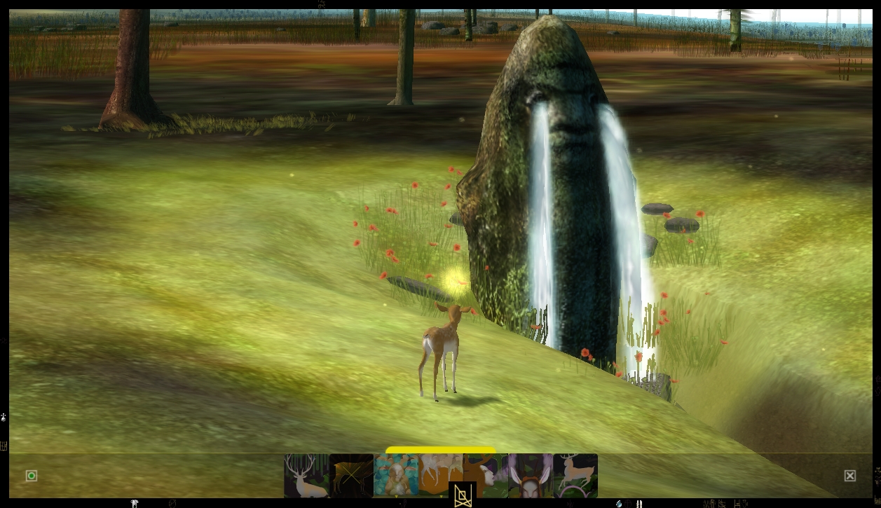
The open ended game play is absorbing, you are drawn into a world in which you move freely in all directions, encountering landscape, architecture, artifacts and other players with little guidance as to how to act. Game play is an experience of learning to live the game world, guided by simple image icons that change dynamically to access appropriate actions. I am still learning to enjoy and explore the world of the Forest, and the game system rewards long-term play with a developing avatar and new action options.
So, it strikes me that these simple, open games, embody much of what I would like to see in the adoption of game technology for engaging with heritage. Imagine freedom from the scripted path of traditional games, a freedom to explore and encounter. Perhaps even a stripping of the strict rules of linear time, so that one encounters echoes of the entire past in a rendering of the present landscape. I see such games as released from the requirements of strict historical accuracy, more a fusion of history, drama and art in which a combination of game play, visual richness and evocative content draw players to explore place, time and space and in so doing create their own meanings.
Tweet
Thursday, 14 April 2011
Igloo: Games and Installation Art
This week I was fortunate enough to stumble upon the work of artists Ruth Gibson & Bruno Martelli a.k.a. igloo who, in their own words create installations, video works, online projects & performances which have been shown in galleries and festivals worldwide.
Their installation VISITOR is currently at the Djangoly Gallery, Nottingham. Inspired by experiences of the Canadian Rockies, VISITOR fuses art and games, with part of the installation Vermilion Lake comprising a full-scale replica of a trappers cabin housing an interactive virtual environment navigated by visitors by the physical means of a rowing boat.


This is a fascinating and hugely creative use of game technology to engage with real and imagined landscape in a visually and physically involving way. In the words of Richard Ducker Curator of the Fieldgate Gallery "The worlds they create are total simulacrums: there is no separation between the invented & the real, the site & the represented, the local & the imagined...Their work engages the particular of the site while undermining its place, the original & point of departure become one in a conceptual unravelling."
Their installation VISITOR is currently at the Djangoly Gallery, Nottingham. Inspired by experiences of the Canadian Rockies, VISITOR fuses art and games, with part of the installation Vermilion Lake comprising a full-scale replica of a trappers cabin housing an interactive virtual environment navigated by visitors by the physical means of a rowing boat.


This is a fascinating and hugely creative use of game technology to engage with real and imagined landscape in a visually and physically involving way. In the words of Richard Ducker Curator of the Fieldgate Gallery "The worlds they create are total simulacrums: there is no separation between the invented & the real, the site & the represented, the local & the imagined...Their work engages the particular of the site while undermining its place, the original & point of departure become one in a conceptual unravelling."
Friday, 18 March 2011
Engaging with the Virtual World
I'm pleased to say that our session at VIA2011 has been accepted by the conference organizers and promises some interesting discussion and debate on the role of games in archaeological visualization.

The six papers are listed below, with full details of the session and the conference on the VIA website.
Tweet

The six papers are listed below, with full details of the session and the conference on the VIA website.
| |||
| |||
| |||
| |||
| |||

Tweet
Friday, 21 January 2011
Brytenwalda
Thanks to Dan Jackson for pointing me towards this movie of a rather nice mod to Mount and Blade Warband called Brytenwalda. Not, I admit, a game I am familiar with, and perhaps no great loss there, but the graphics are fun, even if the concept of Dark Ages and the misplaced iconography of Stonehenge a little confused.
Subscribe to:
Posts (Atom)